
Port-Dock Rail Station Project – September Update (21/9/23).
- Background: PortBUG has had several meetings with the Port Dock Project Team over the last few months. The Outer Harbor Greenway passes directly through the area covered by the project’s. A number of local cycling & pedestrian routes between residential locations & Port Adelaide’s CBD (with its shopping, civic & service centres) were also directly affected by the project.
Our initial agenda in attending these meetings was to identify key issues that the design of the project raised for the main users of the Outer Harbour Greenway (which passes through the project area) – local & commuting cyclists & pedestrians – and for local residents. In subsequent meetings we have acknowledged issues that are (to use the project’s terminology) ‘out of scope’ & sought to make the best of all possible outcomes for all involved – including the prospective users of the new rail station!
Joint meetings have included representatives from PortBUG, BicycleSA & the PAE Council, although more recently the project team has been meeting with stakeholders separately. This update attempts to capture issues discussed (& in some cases resolved) over the last 2 meetings in September.
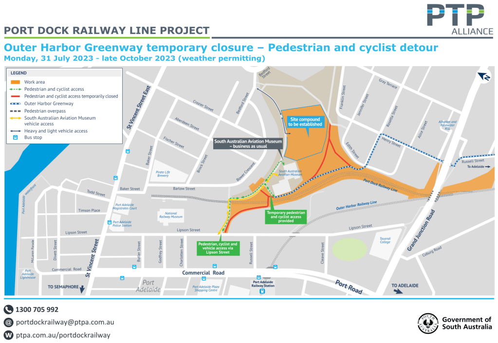
2. Closure of the Greenway’s Rail-Crossing & Lipson St Access: This closure was our major initial concern. The project indicated that this closure was consistent with current Government & Ministerial policy regarding the ‘minimisation of level crossings’ at every opportunity. Project staff also stated clearly that any replacement of the current ‘passive’ at-grade crossing with a suitable alternative – an ‘active’ or ‘automatic’ (servo-controlled & gated) crossing or even a bridge) – was out-of-scope, both in terms of project outcomes & the funding available.
There are a number of significant impacts that the crossing closure will have for all users of both the Greenway & local access routes. Greenway users will in future be routed to the North (Birkenhead Bridge Bikeway) & the west (Jervois Bridge Bikeway) via Barlow, Baker & Todd Streets, with an exact route through the Waterfront yet to be determined.
The PortBUG has a number of reservations re this outcome & has set the issue aside for possible resolution at a future date. Pathway users – previously able to directly access the Port CBD areas from Lipson Street via a number of routes across Commercial Road – will now be routed:
- some distance to the south over the Red Hill Bridge (Grand Junction Road) on the southern edge of the project area & connecting to the southern end of Lipson St, or…
- around the northern end of the rail track extension through the new Station Precinct & joining Lipson Street at the entrance/exits of the newly renovated Bus Interchange (currently often referred to as the ‘Rail Museum Car Park’).
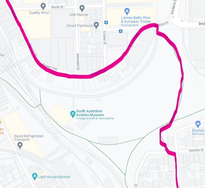
Greenway users proceeding to the north & west will be able to continue on over a new passive crossing arrangement on St Vincent Street (see below) & a route through the Waterfront, yet to be formally determined. They will also be able to gain more direct access to the Port River Expressway via the Gillman Rail Reserve pathways (or Bedford Street) & the Perkins Drive Bikeway, & via Wauwa Street & associated pathway linkages (discussed but yet to be established).
Currently, while the passive rail crossing & dedicated access point on Lipson Street have now been permanently closed, a temporary crossing & access point along the Aviation Museum access roadway will remain open until the end of October (see timeline outlined below).
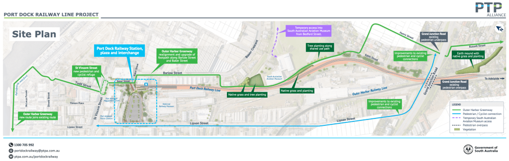
3. Cyclist Access & Refuges at the St Vincent St Crossing: The median refuges & hand/standing rails have been confirmed. Planning is still discussing options for kerb-side standing zones with Council. It’s complicated by the need to maintain ‘through’ bike lanes & a disabled car park outside the Law Courts (where the crossing is located). There is a standing or waiting area planned for the northern side of St Vincent St – it’s only the south side that is at question.
4. New Lighting on Barlow St: Need for 3 new luminaires has been identified. The project will discuss this with Council for their lighting program later this year.
5. Grand Junction Road/Red Hill Bridge Ramp & Pathway Upgrades: Confirmed that:
- a new section of the ascending ramp (adjacent to the exit from the tunnel under GJRd) will be built to improve grades & alignment. A new section of hand rail will be installed.
- the ascending & descending pedestrian/bike ramps at each end of the Red Hill Bridge will be resurfaced & improved with the current lighting poles relocated & possibly new hand rails installed.
- The pathway resurfacing on the ramps may facilitate some widening of the pathways – yet to be determined.
- a redesigned junction of the descending pathway at the end of Lipson St is currently being discussed with a view to improving access & safety & to assist pedestrian/cyclist separation.
- For future discussion – more effective street lighting at this point.
6. Temporary & Permanent Signage Installation: Considerable time was spent discussing the need for signage around the Project. The Project Team will install temporary signage at several ‘decision’ points around the project & reflecting the different stages of the Project as it develops. Permanent OHG & other signage will be installed as the routes become clearer or are finalised. The Team have undertaken to produce a Plan indicating sign location asap.
7. OHG Route through the Waterfront Precinct: For many years, the ‘formally’ designated route has followed the original DIT plan, along the Wharf. As most OHG users will know, this route is impractical & unnecessarily hazardous most of the time (indirect, blind corners, poor surfaces, many obstructions & a crowded cycling space). Most users proceed along the Divett/Nile Street or McLaren/North Parade routes. The PortBUG will be asking Council to resolve the question of a ‘designated route’ asap as it will determine the locations of permanent OHG signage.
8. Pedestrian Access – Lipson Street Crossing Adjacent to Bus Interchange: The BUG had expressed concerns that no provision was made in the original upgrade plans for the increased numbers of pedestrians we anticipated would be crossing Lipson St to access the new rail station, particularly at ‘commuter times’. The area we were concerned about is directly adjacent to the 2 entrance/exit roadways in the Bus Interchange/car park area. They are relatively close to the St Vincent St corner & to the entrance to the adjacent SAPOL car park. A concept plan for an improved passive pedestrian crossing arrangement is currently under discussion with Council. The idea would be to provide 2 designated crossing points (with kerbside protuberances & standing zones) with some questions remaining about need for lighting.
9. Timelines: More detail regarding the Project’s timelines is being sought – the current temporary redirection of the OHG through the Project’s work area is likely to change at the end of October with Greenway users redirected to 2 options – the route over the Redhill Bridge to the southern end of Lipson St or via a somewhat longer route from Edith &/or Henry Streets (see below), over the eastern end of the Gillman Reserve to Bedford St, thence to Bower, Barlow, Baker etc.
PortBUG will write to Council shortly about a number of issues mentioned above & will be meeting again with the Port Dock Project Team in October.
Sam Powrie, Secretary, PortBUG.


The shared path along the waterfront is rarely that busy, and an attractive feature of the Greenway.
LikeLike
It is indeed scenic Brian. However when there are crowds about it has proved an unsafe & inefficient route. Most comments we get indicate that daily commuters rarely use it. The preferred route appears to be via Nile St or McLaren/North Parades…
LikeLike