This page is under construction! It will (eventually) provide a brief outline & maps of each of the Port Adelaide/Enfield Council Area’s main cycling routes with links to more detailed information.
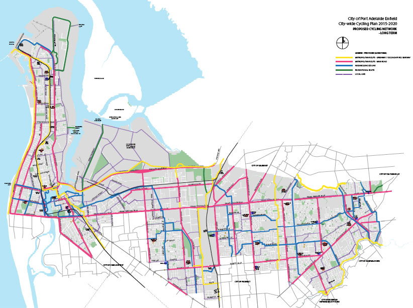
Port Adelaide/Enfield’s Proposed Bicycle Network.
Ride the 21km between the Le Fevre Penninsula and the Adelaide CBD safely and easily! Most of the route is on off-road pathways or traffic-calmed local roads and railway boulevards.
All main road crossings are either
light-controlled or are provided with underpasses or bike bridges! The OHG connects to local cycling networks along the way. The PortBUG’s printable A4 map can be found
here. DPTI Greenway page and directions
here. The OHG is best understood as two sections:
- The ‘Port Connector’ – Adelaide CBD to the Port Adelaide Waterfront (approx 13km)
- The ‘Peninsula Pedaler’ – The Port’s Waterfront to Outer Harbour (approx 8km).
The Port Connector Pathway at Woodville. (pic, DPTI).
This is the main Greenway between the Adelaide CBD and Parklands and the Port Adelaide Waterfront. In many ways it is Adelaide’s pre-eminent cycleway. It’s a secure route that we reckon is suitable for a wide range of ages and abilities. Very young children should be accompanied by adults but older children (perhaps 8-10) should have no problems once they are familiar with the route and with community bicycle use (when to take to the footpath, crossing at lights etc). It’s a picturesque and interesting ride, pleasant and well lit with controlled crossings or bridges/underpasses
at all main roads. There are several parks along the way as well as some coffee/food stops. Eventually we hope to see lots of signposts to local routes, shops & services as well! The Port Connector links to a number of local bike networks and pathways and passes close to all of the rail stations between the City and Port Adelaide (so you can always catch the train home!)

Follow the Sharrows!
Port Waterfront to the Outer Harbour Recreation Park Lookouts – about 8km, mostly on quiet local roads with some shared-use pathways and several off-road connectors between adjacent streets. The route is signposted (blue and white ‘Greenway’ signs) with most of the road surface marked with
sharrows. There are some uncontrolled road crossings involved and primary-age children should be accompanied by adults until they are quite familiar with the route.
We believe that the ‘Pedaler’ has been developed
mainly as a practical and secure route for residents and workers traveling to The Port’s shops & services – see the route
here. For a change, those using this route to ride to Outer Harbor can return to Semaphore and/or Port Adelaide via the scenic Coast Park Bikeway (remember – it’s a shared-use path and often heavily used!)
Catching the train home is also easy as the route travels close to the Outer Harbour Rail Line and several rail stations.
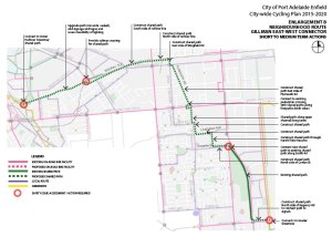
2.

The East-West Connector
(under construction…)
3. Port CBD Bicycle Access:

4. The Parks Connector
The Coast Park(
under construction…)
5. The Mersey Road Bikeway(
under construction…)
6. The Harbour Loop Path West (
under construction…)
7. The Harbour Loop Path East (
under construction…)
8. The Hart Street Bikeway (
under construction…)
9. Esplanade & Victoria Road Loop (
under construction…)
10. The Levels Bikeway (
under construction…)

11. The Gawler Greenway (
under construction…)
12. Military Road (
under construction…)
13. The Rosewater Loop (
under construction…)
14. Causeway Road Bikeway (
under construction…)
15. Semaphore Road Bikeways
(under construction…)
16.
Port River Bikeway: The
Port River Bikeway runs alongside the Expressway of the same name. It connects the Port’s
Inner Harbor Bike Network to major local and longer distance routes, including the:
- Tapa Martinthi Yala Bikeway – connects to the Salisbury Bike Network and routes beyond to Nuriootpa
- he Gawler Greenway – connecting to Mawson Lakes and points beyond to the Gawler Bike Network.


