Hi Folks, admin/BuG secretary here – I thought it might be a good time to provide BUG members with a reminder re. opportunities for direct input to the PAE Council’s ongoing implementation of the Bike Plan.
Although there’s a need for continued focus on gaps in PAE’s ‘arterial bike network’ (secure inter-suburban bike routes), the Council is also now able to focus much more on establishing ‘secondary’ or feeder routes, safer routes-to-schools, better footpaths & ramps, crossings & refuges, speed limits, bike parking & all the other more minor works that make bicycle use and walking more secure & attractive!
Accordingly Council are maintaining an online interactive ‘Out & About’ map that allows community members to identify needs for specific works by type& location, with regular updates indicating progress & installation.
The PAE council area is enormous so identifying local needs is both an ongoing & overwhelming task! Both PortBUG & Council agree that community inputs are ESSENTIAL for a satisfactory outcome! You are encouraged to indentify any of the infrastructure needs mentioned, go to the Out & About map & nominate what is needed there (see link below).
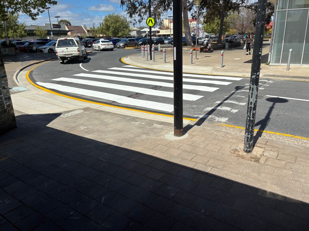
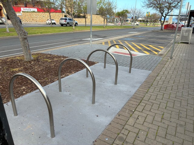
I know personally that the nomination process works having now seen installation of several improvements I’ve & others have nominated, including:
much improved pedestrian ramps & a new crossing on Quebec St in the Port Adelaide Mall shopping precinct &…
new bike parking facilities in the cafe strip at Semaphore (see below).
We’ve been very impressed with such responses & the level of attention & commitment to Active Travel shown by PAE’s planning & transport officers. However they are few in number & they need your help – so please check the map out & ‘have your say’!
Port Adelaide Enfield Council advise that there will be a road closure on the Outer Harbor Greenway tomorrow (Saturday 1st March) for the 10th Birthday celebrations of Pirate Life Brewery.
Barlow Street, Port Adelaide will be closed to traffic.
PAE recommend detouring via Lipson Street (& the Red Hill Bridge pathway).
Super Tuesday, the Australia-wide bicycle commuter survey is rapidly approaching – only 10 days to go! This year Port Adelaide/Enfield Council will participate, gathering data to support the ongoing funding, development & maintenance of its Bikeway Network.
To gather this information PAE needs people to volunteer for 2 hours on the morning of Tuesday 4th of March to count passing bike traffic at key locations across the council area. The survey will be coordinated by both Bike Adelaide & the Bicycle Network. Several locations have been selected:
on the Outer Harbor Greenway at the Red Hill Bridge/Grand Junction Road underpass (adjacent to Henry Street)
linking to the Port River Bikeway & Gawler Greenway at the junction of Magazine Rd & Hensche St, Wingfield
on the Levels-City Bikeway at Grand Junction Road
on the Outer Harbor Greenway/Inner Harbour Loop – the Birkenhead Bridge & Nelson St (to be confirmed)
on the Levels-City Bikeway at Galway/Regency Road (to be confirmed)
Outer Harbor Greenway – Aviation Museum
River Torrens Linear Park – Dernancourt
River Torrens Linear Park – Klemzig.
If you’d like to volunteer please put your hand up ASAP!
Semaphore Road section of the OHG to be temporarily closed.
Path Closure Scheduled for the Outer Harbor Greenway:
PAE Council has notified the BUG of a temporary closure of sections of the OHG along Nelson Street & Semaphore Rd East (see photo below).
The closure (marked on the arial view below in red) is due to the ongoing Cedar Woods housing development at Fletcher’s Slip & need to construct a retaining wall and new pathway connections.
The closure will be in effect for about 10 weeks from 10 February until 28 April.
A detour (marked in green below) will be in place for users of the Greenway bikeway, commencing on the southern (Port-CBD) side of the river, following:
the waterfront paths to Hart Street &…
over the Jervois Bridge off-road bikeway, & thence to…
the Causeway Road off-road pathway (see below).
Council will provide signs to assist with navigating this temporary route.
A possible alternative: The BUG notes that it the proposed detour could add some extra travel distance to the OHG route, depending on direction of travel & starting point or destination. We also note that the section of pathway between the Birkenhead Bridge & the push-button crossing at the junction of Semaphore Rd & Nelson Street will apparently remain open. While this will make life a bit easier for the pedestrians & mobility device users who also make use of the OHG route, but it also seems to offer an alternative ‘footpath’ route for bike users who don’t mind a bit of ‘back & forth’ across Semaphore Rd (see blue line marked ‘Pedestrian Detour’)!
Regular users of these sections of the Greenway will need to make their own choices depending on their destinations & direction of travel…
Local MPs Susan Close & Joe Szakacs have called a Community Update Meeting for those interested in the future of the proposed Rosewater Loop recreational space & greenway.
Where: Rosewater Bowling Club, 132-134 Grand Junction Road (enter off Kelmscott Rd)
When: Saturday 15th February, 10.30 – 11.30 am.
RSVP: By Tuesday 11th February Ph: 8243 0062 or cheltenham@parliament.sa.gov.au
BUG & Local Community members are strongly encouraged to attend!
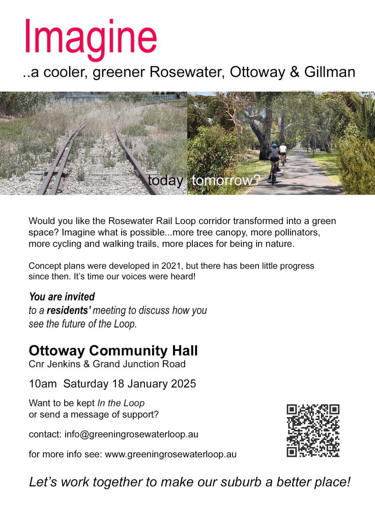
Further to our last post, Melanie Carter from the newly-formedRosewater Loop Group writes:
“Thanks for promoting the Rosewater Loop residents meeting on your PortBUG Website. The Greening Rosewater Loop Group has now launched a website, and we have an email address.
Attached is a poster with more information and links [Ed; see below]. The meeting on Saturday 18th January at 10am [Ottoway Community Hall, Cnr Jenkins St & Grand Junction Rd] will focus on community input. PortBUG has long supported the development of the Rosewater Loop and we would appreciate input from your members.
Many thanks, Melanie Carter, Greening Rosewater Loop Group”
PortBUG congratulates the Greening Rosewater Loop on these great initiatives. The ‘Loop’ has potential to provide much needed ‘green space’ for Rosewater & neighbouring Ottoway – suburbs that have both become quite ‘hemmed in’ & isolated by heavy vehicle traffic (on Grand Junction Road) & the much-neglected Gillman rail reserve. Both suburbs are much in need of community-space generally.
Construction of the Loop (& associated pathways on the Gillman Reserve) will ensure that residents of Rosewater & Ottoway have substantially improved green-space as well as secure pedestrian & bicycle access through to the Port CBD’s shops & services & further afield. The ‘Loop’ will also ensure that residents can connect to the Outer Harbor Greenway – a secure bike route travelling all the way into the Adelaide CBD – as well as train transport at both Alberton & the new Port Dock rail stations.
PortBUG encourages all those interested in development of the Rosewater Loop to check out the Group’s new website, attend the meeting at 10am on Saturday 18th January &/or sign up via email to be kept ‘In the Loop’!
Council Activities: PortBUG has recently met with Council Staff & has been very encouraged to hear of some quite major works planned for the current & next financial years to further implement the PAE Bicycle Network.
We are somewhat limited in the detail of what we convey at this stage but look out for major announcements on new bicycle routes & infrastructure within the Port CBD & along the Mersey Road Bikeway & Outer Harbor Greenway.
Council is also involved in several exciting longer-term planning activities aimed at improved connectivity along an ‘East-West’ connector across the Council area, and new linkages through to the Salisbury Council’s bike network to the north as well as provision of a new ‘bike page’ at their web site.
PAE residents are fortunate in having a Council in which both staff & elected members have demonstrated genuine interest in supporting bicycle transport & active travel generally! It’s important that residents reciprocate this interest & support Council’s efforts to invest in bicycle infrastructure & build a truly effective & connected walking & cycling network!
State Transport Strategy: Recently the State Government conducted public consultations for a new ’30 Year’ State Transport Strategy. The PortBUG made a brief & (hopefully) to-the-point submission which you can read here.
There have of course been a number of similar planning activities over the last decade or two & it has often seemed that submissions regarding active transport & cycling go unheeded! However PortBUG remains hopeful that planners & decision makers within DIT & Government will eventually put ‘two-&-two together’ & understand the enormous potential benefits to be had from appropriate investments in a connected & secure bicycle network for Adelaide & SA!
The BUG Coordinating Group would like to take the opportunity to wish everyone a safe & happy Christmas. Sam P. (Secretary).
Note that the Council has an ongoing Participate PAE consultation open at their website whereby residents can nominate ‘on the map’ needs for bike parking, kerb ramps, accessible parking and pedestrian and cycling refuges?
Matt Hutson, Traffic & Transport Planner at PA/E Council has provided the following Cycling & Walking updates:
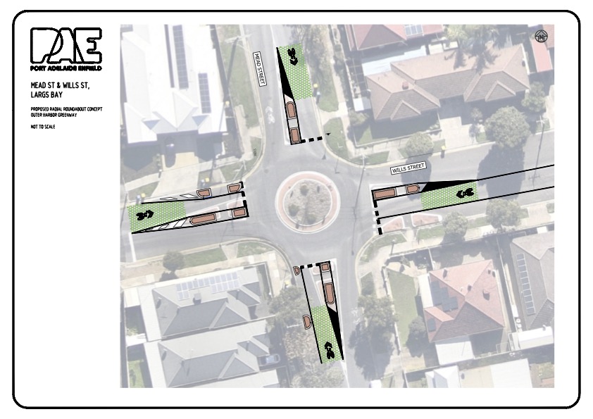
1. Mead St & Wills Street Roundabout Design: Council will shortly put out consultation for Black Spot funding proposals for the next financial year (2025/26) along the OH Greenway, including a new roundabout design for the Mead/Wills Street intersection (see below). This roundabout constitutes a key road intersection on the Northern section of the Outer Harbor Greenway. The proposal is to upgrade the existing ‘tangential’ roundabout to a ‘radial’, inspired by SA’s latest Active Travel Design Guide. It will include new patterned line marking on the approach to the roundabout in the shape of green hexagons or honeycombs. Sharrows will then be placed centrally to alert drivers of cyclists and to support cyclists to ‘claim the lane’ when entering the roundabout.
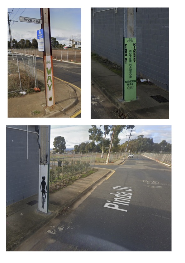
2. Paint Ya Pole: The BUG has been discussing a range of strategies with Council to provide more effective route, destination & directional guidance on the Outer Harbor Greenway. Some weeks ago Matt contacted the BUG with an initial proposal to get a group of interested community members together to add some artwork to the Greenway by painting stobie poles (see examples below). Matt has proposed an on-going & free painting activity organised by City of PAE .
Examples of painted poles along the OHG within the Charles Sturt Council Area.
Council has acknowledged that finding or sticking to the Greenway’s route has been a challenge for those unfamiliar with it, particularly as it approaches & transits through Port Adelaide. When it comes to providing directional or destination guidance, painting the Stobie poles along the way could be seen as one of the ‘low hanging fruit’ options in highlighting the route, complementing some of the other more formal signage & route guidance proposals that have been discussed. If you are at all interested in participating in a Stobie Pole painting project please contact the BUG’s secretary asap.
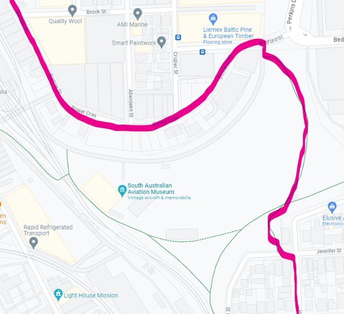
3. Bedford Street Bike Lanes (safety strips/buffers): Matt reports on the imminent installation of new bicycle lanes on Bedford Street, Port Adelaide between Gray Terrace & Perkins Drive (& its off-road bike path) with possible delivery by end of November. This project will connect to a proposed new wombat crossing at Gray Terrace (to be delivered in FY24/25) & will effectively provide a Port CBD ‘by pass’ option between the Outer Harbor Greenway & the Port River Bikeway.
4. Walking Improvements: PAE Council are currently focusing on improving pedestrian ramps throughout the suburb of Enfield. The key focus is around schools, shops, aged care facilities and parks. This will ensure the kerb ramps are compliant with current DDA requirements. Council also have an ongoing ‘Participate PAE’ online consultation you can use to suggest upgrades to ramps, crossings, bike parking & other walking & cycling infrastructure across the Council Area. PortBUG encourages all residents to contribute their suggestions here.
5. Active Transport Fund: The Federal Government’s new Active Transport Fund is now open. It can be found here – https://investment.infrastructure.gov.au/about/local-initiatives/active-transport-fund Applications close 13 January 2025. Matt will keep the PortBUG updated on Council’s chosen projects and any consultation opportunities that arise.
6. Bike Lane Proposal for Military Road: Council has been approached by the RAA about the possibility of bicycle lanes along Military Road (currently posted at 60km/h) – the RAA apparently intend writing to DIT proposing them. Council have drafted a letter supporting this initiative (Action Item #79 in the Walking & Cycling Plan).
7. Treweck Avenue, Hillcrest (new bicycle ramp): As part of Council’s Road Renewal program, Matt has identifying roads that would benefit from improved cycling infrastructure. Matt has identified need for an additional ramp to complement the newly installed pedestrian and cyclist refuge at the corner of Patricia and Treweck Avenues, Hillcrest. This should make access to the footpath and the new refuge island easier and safer. Matt will share a concept plan once prepared. Delivery should be in this financial year.
8. Budget Planning – 2025/26: Matt is working on the Walking & Cycling program for next financial year (2025/26) and will share this in coming weeks.
In particular he has:
scoped some works mentioned in the Walking & Cycling Plan (Action items #7 to #10) that need to be completed in Angle Park as well as various key projects in the Port CBD (Action items #92 to 113)
been exploring further improvements to the Mersey Road Bikeway to connect to Veitch Road & the Osborne Naval Shipyards with Renewal SA and the ARTC.
Matt will put some concept designs out for consultation once plans are complete.
World Car Free Day: The PAE Council is hosting key local activities to mark & celebrate World Car Free Day & encouraging residents to get involved – by attending the events & considering their own car-free possibilities, either on the day, over the week or on an ongoing basis.
From the Council: “World Car Free Day is on Sunday 22nd, but we are aiming to get more people active during the week and celebrate the event on Thursday, with the aim for a ‘car free week’.”
PAE’s World Car Free Day events:
Pop-Up Information Stalls: The PAE Visitor Information Centre will be hosting pop-up stalls with resources available to learn more about active transport options and the network of trails and paths to explore the area. We will also be giving away free coffee and muffins to active transport commuters.
When: Thursday, 19th September, 7:30 am – 9:30 amWhere: Port Dock Railway Station. Lipson Street, Port Adelaide.
The Port Environment Forum: The Forum is hosting an event that will include two guest speakers:
– David Stephenson from the Port Adelaide Living Streets Alliance, who will discuss the active transport vision for Port Adelaide
– Sam Powrie from PortBUG, who will share information about the BUG’s work & the Outer Harbor Greenway.
When: Thursday, 19 September, 7 pm – 8:30 pmWhere: Town Hall. 34 Nile Street, Port Adelaide.
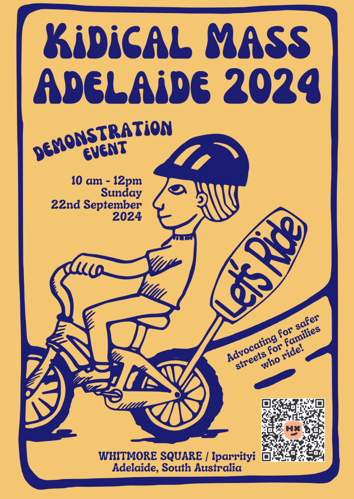
“Join the City of Adelaide for a free family event that invites you to immerse yourself in the world of cycling. Celebrating World Car-Free Day, bring the whole family for a day of exploration and fun in beautiful Whitmore Square / Iparrityi. Suitable for all ages, discover the latest bike models and gear up for interactive riding activities.”
“KIDICAL MASS – CHILD FRIENDLY AND CYCLE FRIENDLY CITIES…
From big cities to rural areas, we as the Kidical Mass action alliance are united by the vision that children and young people should be able to move around safely and independently on foot and by bike. Safe streets and active mobility for children and young people is the key to the mobility transition! Children who are active by bike and on foot from an early age remain so as adults. With our campaigns – especially the Kidical Mass bicycle demonstrations, the school streets and the bike bus (Bicibús) – we paint a positive picture of the future and make change tangible. The Kidical Mass action alliance consists of over 700 organizations, associations and initiatives from Canada to Australia.”
Port Dock Rail Station Now Open! The new Port Dock rail station & line extension is now open, as are the new routing arrangements for the Outer Harbour Greenway through the precinct & connecting to the Waterfront (& points to the north). We’ll cover the new Greenway arrangements in a separate post but you can read about the new station here.
2. From Bicycle Dutch: Just Mesmerising!
“This August marks the five-year anniversary of the grand opening the world’s largest bicycle parking garage in Utrecht, which has been fully operational since 19 August 2019. In this week’s video we take a look at people entering and exiting the garage in a steady rhythm that can increase to two bicycles a second on average at peak hours.”
3. Mersey Road Bikeway – More Upgrades: Port Adelaide/Enfield Council is continuing its focus on upgrading the Mersey Road Bikeway, recognising it as an important access route for workers at the new SubCorp site at Osborne & with a focus on reducing risks for cyclists associated with heavy vehicle movements in the area. PortBUG is currently consulting with council on draft plans – look for further updates & details later this year.
4. New Infrastructure Planned! PAE Council is drafting plans for new & more localised cycling-related infrastructure across the council area. PortBUG is reviewing these plans & responding to council accordingly. We’ll be able to share more details a bit further down the track with construction commencing later this financial year. Currently the draft plans include works on:
Lady Ruthven Drive: Widening the shared-use path.
Mead Street / Shorney Street: Improving the ramp design.
Fletcher Road: Improved footpath & refuge access.
Osborne Road: Widening the pedestrian refuge island access, improving reconnect to the greenway
Klingberg Drive: Will include a new pedestrian and cyclist refuge.
Some additional projects in the pipeline will include works on Elder Road, Bedford Street, Gray Terrace, and the Dry Creek/Valley View shared-use path.
PortBUG would like to congratulate PAE Council on its continued, and indeed its growing support for walking & cycling, & for Active Transport generally! This support is realised not just the in the greatly increased annual funding allocated to implementing the PAE Walking & Cycling Plan, but also in the very obvious enthusiasm & ‘hands-on’ participation demonstrated by council staff in supporting the Plan (which has included regularly meeting with the BUG’s coordination group AND getting out on their bikes for on-the-ground ‘saddle surveys’).
We also note that PAE Council is now a Healthy Streets Practitioner!Congratulations all around!
June Meeting Summary: Your BUG held a very productive meeting with staff from the Port Council’s Transport Team. It was pleasing to note that after several years working mainly on larger scale projects (such as the Outer Harbour Greenway & other bikeways), the most recent 2022 Walking & Cycling Plan (https://www.cityofpae.sa.gov.au/__data/assets/pdf_file/0015/413016/Local-Area-Bicycle-Plan.pdf) has been able to focus on much more ‘granular’ issues – bike parking provisions, local pedestrian & bicycle access & continuity, neighbourhood bike routes & safe crossings at main road intersections.
This focus on smaller-scale issues was reflected in much of our discussion with the Transport Team. Key items discussed included:
St Vincent St: an extensive street-scaping project planned for St Vincent St. We hope this will resolve a number of pedestrian & bike-lane issues on this important route into & through the Port CBD.
Port Dock Station Project: Upgrading of footpaths & bike lanes on & around Lipson & Godfrey Streets, new bike crossings on St Vincent St (adjacent to Todd St) & new pedestrian crossing points on Lipson St.
OHG Review: Council is undertaking a review of the Outer Harbour Greenway (Alberton to Outer Harbour).
Improved Bike Network Guides: Provision of effective online bike-network mapping & in particular, better guidance for OHG users. Staff are exploring various options including a phone app, use of Google Maps, en-route QR Codes & various forms of in-situ guidance & signage.
Pedestrian Upgrades: A new pedestrian ramp & signals will be installed adjacent to the Nelson/St Vincent St corner along with new Bike/Pedestrian Activated signals on the Levels-to-City Bikeway crossing on Grand Junction Road near Montrose Ave.
Port CBD Project & CBD LATM: Council hope to commence a Local Area Traffic Plan (LATM) for the CBD mid-2025. The City Development Team is also undertaking a Waterfront Precinct Plan, which will include consideration of priority bike routes for Greenway users through the Waterfront area.
Access to Schools Funding: Staff are committed to a review of local access, infrastructure & parking issues for all 31 schools in the PAE Council area & potential for improvements. Currently seeking funding.
Priorities for the 2024-25 Financial Year: Staff outlined several projects including:
– Outer Harbour Greenway improvements
– improved arterial road crossings
– a new pedestrian crossing on May Trc, Rosewater
– new bike lanes on the Mersey Road Bikeway
– St Vincent St streetscape upgrades
– Lipson & Godfrey Street pedestrian & bike upgrades
– pedestrian & bike upgrades, Bower & Military Roads
– new bike parking rails – 9 to date & 10 more planned for 2024-25.
We also discussed the new Federal Active Transport Fund. We have proposed use of this fund to resolve major crossing/underpass safety issues on the Port River Bikeway (for which DIT are responsible). Staff will be keeping an eye on opportunities to access such funding & encourage DIT to resolve the issue.
PortBUG found our discussions with Council staff encouraging & look forward to working with them further over the coming year.
New meeting arrangements: PortBUG now meets bimonthly (ie; we’re aiming for 6 meetings per year). BUG & Forum members are welcome to attend – just email the BUG secretary (Sam at portadbug@gmail.com) for dates & times.
Last week PortBUG held it’s first meeting for the year. Over 2023 we found it quite difficult to get together due to illness & life’s many other commitments. Over 2024 we have agreed to reduce our meeting frequency with get-togethers every 2 months. Hopefully this will allow us to meet a bit more consistently.
It’s worth noting that the 5 members of your current BUG Coordinating Group are all getting older & to be frank, representing the case for Active Transport gets a little more challenging with each passing year. However we are all very fortunate to have an interested & engaged Council & there many opportunities remain to improve the walking & cycling environment across the Council area!
So you are interested in seeing the positive impact of the PortBUG continue & would like to get a bit more involved, your participation as a Coordinating Group member would be most welcome – contact the Secretary at portadbug@gmail.com
We discussed a wide range of issues at our initial May meeting, including:
1. New Salisbury Bicycle User Group: We had an opportunity to hear from Ash Baxter from the newly formed Salisbury BUG. The PortBUG welcomes this opportunity for working collaboratively with its counterpart in Salisbury!
2. Updated Semaphore Foreshore Plan: Liz Millington reports that a number of issues regarding some obvious train/bike & bike/pedestrian conflicts & safety in the initial plan have now been resolved. Council’s Community Consultation Survey is live until Sunday May 19th. The BUG encourages members toreview the revised Plan as well as the FAQ’s & then complete the Survey prior to that date.
There will be a Final Drop-In Session to chat with the project team at the Semaphore BBQ Shelter on Wed 15th May; 4-5.30pm.
3. Update – Port Dock Rail Station Project: Members will have noted the obvious impact this project has had on the Outer Harbour Greenway. Tony Bazely is currently the BUG’s rep to this project & reported on progress with the upgraded pathway over the Red Hill Bridge (between the Grand Junction Rd bike/ped. tunnel & Lipson St) & other related issues. The project is scheduled for completion in July.
4. Recent Greenway Ride with PAE Staff: PAE Council intend reviewing PAE’s section of the Outer Harbour Greenway. How this review will occur is still a little unclear, but BUG members recently went on an initial survey & familiarisation ride with staff from Fussell St, Alberton all the way to Outer Harbour.
Issues discussed included opportunities to improve the Greenway’s route from Buller Trc through to Russell St, Rosewater & potential for an additional route option nearby on the southern side of the rail line. Similar possibilities for improvement were discussed for the Waterfront Precinct and at the northern end of the Greenway. We’ll keep BUG community updated re. this review.
5. Largs Bay LATM: Council will conduct a Local Area Traffic Management plan for Largs Bay. Ann Douglas will represent the BUG in this LATM, but Council will also call for representation from local residents. We’d encourage residents of Largs Bay to nominate to the working group to ensure that walking & cycling issues are adequately represented.
6. E-Bike Adoption Subsidies: The BUG has noted that both Adelaide City Council& the City of Holdfast Bay now offer subsidies for people wanting to purchase & use an e-bike as car-replacement. The BUG will raise this possibility with PAE Council as well.
Ongoing BUG Meeting Schedule: Future BUG meetings will be held bi- monthly (that is, 5 times per year) with the next meeting being in July. Please let our Secretary know if you are interested in attending.
PA/E Council are undertaking final design for enhanced bike lanes along Folland Avenue, Northgate/Lightsview. The intent is to install a line-marked buffer between the existing on-road cycle lanes and the vehicle travel lanes (see example below).
Most of Folland Ave has no central median so there is sufficient width for a 1.5m bike lane with the proposed buffer strip and a motoring lane. However, between Dumfries Avenue & Fosters Road a centre median is present which limits the carriageway width to 5.0m for each direction.
The current arrangement in this section is a 1.5m bike lane and a 3.5m travel lane. If Council continue the buffer lane through this section they would need to narrow the bike lane slightly to 1.3m with a 0.4m buffer strip and a 3.3m travel lane(the 3.3m travel lane is required by DIT for bus routes).
Council are seeking feedback on which would be the better outcome for this section of Folland Ave – the existing arrangement of a 1.5m bike lane & 3.5m travel lane (ie; without a buffer lane) or a slightly narrower bike lane (1.3m) with a 0.4m continuous buffer. See below for draft layouts for these 2 road treatment options.
Please let us know what you think via email at portadbug@gmail.com by this coming Friday 23rd Feb (if you are on facebook you can already read some interesting comments from members at our f/b BUG Forum at https://www.facebook.com/groups/portadbug/.
As part of the Port Dock Rail Station & Line Extension Project, new landscaped areas will be created to offset the vegetation removed and to enhance local amenity.
The PTP Alliance invites the community to meet members of the project team, to view the project’s landscaping plans & planting schedule and to ask questions about the project.
Where: A Community Drop-in Session will be held at the City of Port Adelaide Enfield Town Hall, at the corner of Nile Street and Commercial Road, Port Adelaide SA 5015.
Access to the City of Port Adelaide Enfield Town Hall is available via Nile Street or via Commercial Road. Ramp access is provided at the Commercial Road entrance.
When: Saturday, 3 February 2024, anytime between 10am and 12pm.
Readers will be aware of the Port Dock Rail Project & its impact on the Outer Harbour Greenway route as outlined in previous posts. As a reminder, the proposed final layoutfor new cycling & walking routes are shown below.
PortBUG has continued to meet with the Project & we have now been provided with a map (see below) illustrating the recommended temporary detour routes for Outer Harbor Greenway users (both pedestrians & cyclists) over the course of the project.
There will be twotemporary routes available around the project:
Via Henry St, Rosewater, across the Glanville Rail Reserve to Bedford, Brock, Barlow & Baker Streets &…
Via the existing ramp & footpath route over the Redhill Bridge & thence to Lipson Street.
Note that the Project envisages that:
cyclists may prefer to use the east-side footpaths on Lipson St (& certainly in the vicinity of the St Vincent St corner)
cyclists will use the footpaths along St Vincent Street (green dashed line) adjacent to the Police Station & Magistrate’s Court & across the road between Timpson St & Lipson Street (blue dashed line).
the current crossing point on St Vincent St at the end of Lipson St will be retained.
Also note that:
a new recommended Greenway route through the Waterfront Precinct remains under discussion with PAE Council – probably along Divett/Nile Streets or McLaren/North Parades.
the final Port Dock Project plan will see a two-stage crossing on St Vincent St between Baker & Todd Streets
the ramps & elevated footpath over the Redhill Bridge will be rebuilt as part of the Project. The purple dashed line along Commercial Rd represents (we believe) a possible footpath route that might be taken when this rebuilding takes place (see previous posts for details). Note that rather than proceed back to the Lipson St corner, cyclists may prefer to simply cross St Vincent St at the pedestrian lights (St Vincent St/Commercial Rd corner) to Light House Square!
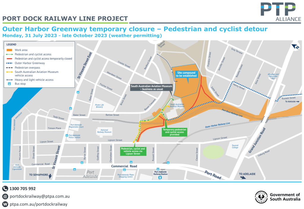
With regard to timelines & signage the Project tells us that ‘The plan is to have all detour signage in place by Thursday, 9 November 2023‘… & ‘ It will be a soft start as the Lipson Street entrance that runs across the rail line to the SA Aviation Museum will be open for a couple of weeks. However there will be construction activity around here and traffic controllers on site will encourage pedestrians and cyclist to use the detours.’ It is believed that the Project will run to about June 2024.
The BUG has requested that entry points to the Project be provided with larger signs with detailed maps illustrating the routes available as well as key destinations, with other directional signs provided at ‘decision points’ along the way.
The Project is keen to ensure that these detours work as well as they can & invites your feedback, either via PortBUG (comments below or our Facebook forum or portadbug@gmail.com) or at the Project’s contacts below:
Port-Dock Rail Station Project – September Update (21/9/23).
Background: PortBUG has had several meetings with the Port Dock Project Team over the last few months. The Outer Harbor Greenway passes directly through the area covered by the project’s. A number of local cycling & pedestrian routes between residential locations & Port Adelaide’s CBD (with its shopping, civic & service centres) were also directly affected by the project.
Our initial agenda in attending these meetings was to identify key issues that the design of the project raised for the main users of the Outer Harbour Greenway (which passes through the project area) – local & commuting cyclists & pedestrians – and for local residents. In subsequent meetings we have acknowledged issues that are (to use the project’s terminology) ‘out of scope’ & sought to make the best of all possible outcomes for all involved – including the prospective users of the new rail station!
Joint meetings have included representatives from PortBUG, BicycleSA & the PAE Council, although more recently the project team has been meeting with stakeholders separately. This update attempts to capture issues discussed (& in some cases resolved) over the last 2 meetings in September.
2. Closure of the Greenway’s Rail-Crossing & Lipson St Access: This closure was our major initial concern. The project indicated that this closure was consistent with current Government & Ministerial policy regarding the ‘minimisation of level crossings’ at every opportunity. Project staff also stated clearly that any replacement of the current ‘passive’ at-grade crossing with a suitable alternative – an ‘active’ or ‘automatic’ (servo-controlled & gated) crossing or even a bridge) – was out-of-scope, both in terms of project outcomes & the funding available.
There are a number of significant impacts that the crossing closure will have for all users of both the Greenway & local access routes. Greenway users will in future be routed to the North (Birkenhead Bridge Bikeway) & the west (Jervois Bridge Bikeway) via Barlow, Baker & Todd Streets, with an exact route through the Waterfront yet to be determined.
The PortBUG has a number of reservations re this outcome & has set the issue aside for possible resolution at a future date. Pathway users – previously able to directly access the Port CBD areas from Lipson Street via a number of routes across Commercial Road – will now be routed:
some distance to the south over the Red Hill Bridge (Grand Junction Road) on the southern edge of the project area & connecting to the southern end of Lipson St, or…
around the northern end of the rail track extension through the new Station Precinct & joining Lipson Street at the entrance/exits of the newly renovated Bus Interchange (currently often referred to as the ‘Rail Museum Car Park’).
Greenway users proceeding to the north & west will be able to continue on over a new passive crossing arrangement on St Vincent Street (see below) & a route through the Waterfront, yet to be formally determined. They will also be able to gain more direct access to the Port River Expressway via the Gillman Rail Reserve pathways (or Bedford Street) & the Perkins Drive Bikeway, & via Wauwa Street & associated pathway linkages (discussed but yet to be established).
Currently, while the passive rail crossing & dedicated access point on Lipson Street have now been permanently closed, a temporary crossing & access point along the Aviation Museum access roadway will remain open until the end of October (see timeline outlined below).
3. Cyclist Access & Refuges at the St Vincent St Crossing: The median refuges & hand/standing rails have been confirmed. Planning is still discussing options for kerb-side standing zones with Council. It’s complicated by the need to maintain ‘through’ bike lanes & a disabled car park outside the Law Courts (where the crossing is located). There is a standing or waiting area planned for the northern side of St Vincent St – it’s only the south side that is at question.
4. New Lighting on Barlow St: Need for 3 new luminaires has been identified. The project will discuss this with Council for their lighting program later this year.
5. Grand Junction Road/Red Hill Bridge Ramp & Pathway Upgrades: Confirmed that:
a new section of the ascending ramp (adjacent to the exit from the tunnel under GJRd) will be built to improve grades & alignment. A new section of hand rail will be installed.
the ascending & descending pedestrian/bike ramps at each end of the Red Hill Bridge will be resurfaced & improved with the current lighting poles relocated & possibly new hand rails installed.
The pathway resurfacing on the ramps may facilitate some widening of the pathways – yet to be determined.
a redesigned junction of the descending pathway at the end of Lipson St is currently being discussed with a view to improving access & safety & to assist pedestrian/cyclist separation.
For future discussion – more effective street lighting at this point.
6. Temporary & Permanent Signage Installation: Considerable time was spent discussing the need for signage around the Project. The Project Team will install temporary signage at several ‘decision’ points around the project & reflecting the different stages of the Project as it develops. Permanent OHG & other signage will be installed as the routes become clearer or are finalised. The Team have undertaken to produce a Plan indicating sign location asap.
7. OHG Route through the Waterfront Precinct: For many years, the ‘formally’ designated route has followed the original DIT plan, along the Wharf. As most OHG users will know, this route is impractical & unnecessarily hazardous most of the time (indirect, blind corners, poor surfaces, many obstructions & a crowded cycling space). Most users proceed along the Divett/Nile Street or McLaren/North Parade routes. The PortBUG will be asking Council to resolve the question of a ‘designated route’ asap as it will determine the locations of permanent OHG signage.
8. Pedestrian Access – Lipson Street Crossing Adjacent to Bus Interchange: The BUG had expressed concerns that no provision was made in the original upgrade plans for the increased numbers of pedestrians we anticipated would be crossing Lipson St to access the new rail station, particularly at ‘commuter times’. The area we were concerned about is directly adjacent to the 2 entrance/exit roadways in the Bus Interchange/car park area. They are relatively close to the St Vincent St corner & to the entrance to the adjacent SAPOL car park. A concept plan for an improved passive pedestrian crossing arrangement is currently under discussion with Council. The idea would be to provide 2 designated crossing points (with kerbside protuberances & standing zones) with some questions remaining about need for lighting.
9. Timelines: More detail regarding the Project’s timelines is being sought – the current temporary redirection of the OHG through the Project’s work area is likely to change at the end of October with Greenway users redirected to 2 options – the route over the Redhill Bridge to the southern end of Lipson St or via a somewhat longer route from Edith &/or Henry Streets (see below), over the eastern end of the Gillman Reserve to Bedford St, thence to Bower, Barlow, Baker etc.
Map courtesy of Robert Kretschmer.
PortBUG will write to Council shortly about a number of issues mentioned above & will be meeting again with the Port Dock Project Team in October.
John Fullbrook MP, Bike Networks & Sals BUG ‘Renewed’?
Recently PortBUG met with John Fullbrook, MP for Playford (part of Salisbury). John is an interesting fellow with a diverse career & is a resident of Mawson Lakes. He expressed some frustration that there was apparently no active Salisbury Bicycle User Group capable of driving, guiding & promoting the development of cycling infrastructure across the Salisbury Council Area. He wanted to learn from us how the development of such a ‘renewed’ Sals BUG might best be achieved & was quite keen to support is any way he can!
PortBUG discussed some of the key issues in forming & successfully operating a BUG (see here). We talked about the potential for bicycle transport in addressing issues such as social & transport equity & economic resilience, and of the central importance of off-roof bikeways & their connectivity & continuity.
The long & short of it is that John:
is very keen to support the development of an active & independent BUG, perhaps similar to PortBUG
is keen to see operational linkages between a SalsBUG & PortBUG, particularly around the continuing development of inter-suburban routes such as the Port River Bikeway (including the notoriously dangerous underpass at Barker Inlet), the Gawler Greenway & elsewhere.
PortBUG indicated we would – in general terms – be happy to support the further development of an active SalsBUG & the Salisbury Bicycle Network, particularly where linkages to & continuity with the PAE Bike Network were involved. We pointed out that the new bikeway facilities that connect Salisbury, Mawson Lakes & points north to the Adelaide CBD & related suburbs already carry quite significant numbers of bicycle commuters as well as quite a number of recreational riders every day.
PortBUG undertook to try to contact those who are currently using these routes (many are likely to be on our Blog & Facebook groups) & refer them to John’s office. So if you are interested in talking with John about a SalisburyBUG &/or working on improvements to the Salisbury Bike Network, he can be contacted at: P: 8250 7234, E: playford@parliament.sa.gov.au.
PortBUG indicated that we’d be happy to collaborate in any way that we can.
2. Port Dock Rail Station Project – Update: On Friday 11th August PortBUG met with the Port Dock Project Team for a discussion of key issues & a site walkover. Reps from BikeAdelaide & PAE Council were also there.
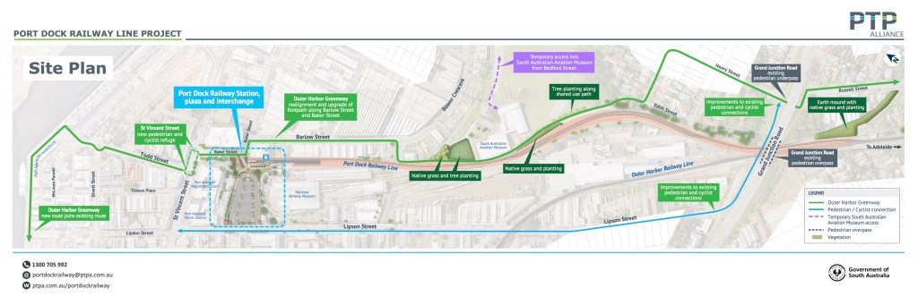
Port Dock Rail Line Project – Site Plan.
We were reasonably impressed with the extent to which the project team has responded to concerns previously expressed. They have of course been unable to address our key issue – maintaining the at-grade crossing for the Greenway & direct access to Lipson St – but they have certainly taken a hard look at other possibilities to improve their initial approach, notably:
accepting need to plan a pedestrian crossing on Lipson St adjacent to the entrance & exit ramps of the bus interchange & railway precinct
design & construction of an effective bicycle crossing on St Vincent St, connecting Lipson St to Todd St
reprioritising of the Bower/Baker St junction to facilitate a more direct Greenway cycling route
creation of better lighting & corner alignments along these streets & links through the rail precinct
significant potential to improve the ramp ways & pathway up, over & down the Red Hill Bridge – the project cannot do much (if anything) to improve the steep inclines, but it does appear that there may be capacity to widen the rampways towards each end of this section.
Also discussed were some broad aspects of work scheduled for the next few months. The various closures, redirections & short-term projects were too numerous to discuss here but in broad terms:
the primary Greenway redirections are now in place
as it stands, current redirections will be in place until mid-October (including a new temporary at-grade crossing where the access roadway for the Aviation Museum was previously located)
there will then be a next stage of Greenway realignment for approx 7 months (ie; to around July 2024), probably providing dual Greenway routes – one over the Red Hill Bridge (& likely best suited to pedestrians visiting the PA CBD) & another skirting the entire project, starting on Russel St, Rosewater & proceeding around the eastern margins of the Gillman Rail Reserve to Bedford St.
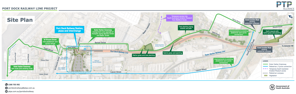
The project has provided maps of detours applying over next few weeks (until around October) & the project’s proposed final site plan (see above). Both are also available at the ptpa’s website: https://ptpa.com.au/projects/port-dock-railway-line:
Note: Don’t take too notice of the projected Greenway route along the waterfront Ifar LHS of the Site Plan above) – we’ve had extensive discussions with Council about a more sensible route (along Nile/Divett Streets or North/McLaren Parades).
PortBUG is meeting with the project team again next week when we expect to see confirmed drawings or the project.
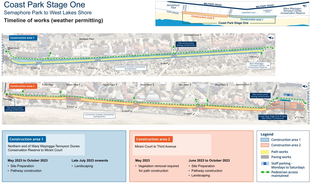
Coast Park Stage One – Semaphore Park to West Lakes Shore.
Construction of Stage One of Coast Park (located between Third Avenue, Semaphore Park and the northern edge of the Wara Wayingga-Tennyson Dunes Conservation Reserve at West Lakes Shore) will begin on Wednesday 17 May 2023. Work is expected to be complete in late 2023, weather permitting.
A site office has been established at Mirani Court and this compound will be used for the duration of the project. Site access will be via Mirani Court, Sandpiper Place and Third Avenue.
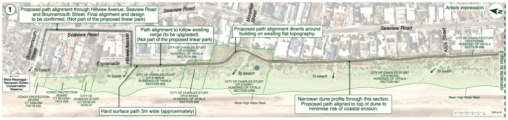
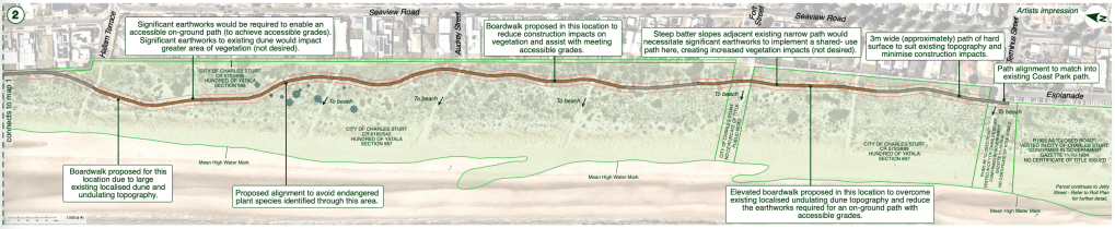
From DIT: Coast Park ‘Stage Two’ – Tennyson to Grange.
Following on from the establishment of the Linear Park, Grange-to-Tennyson, the project team has developed a preliminary design for the Coast Park Stage Two Pathway.
Visit the Plan SA link for the latest News update and to view the preliminary design (currently being progressed).
Industrial Design student Victoria Aceiro has asked for assistance in completing her Masters degree research – see attached note & Mail Chimp survey link. You may like to help her out…
“Hi everyone! I was wondering if you could help me out by doing this short survey which aims to gather information about individuals’ use of bicycles and their perceptions of bicycle safety when leaving their bikes parked. The results of this survey will aid in the research and design of parking facilities and help improve future bicycle infrastructure.
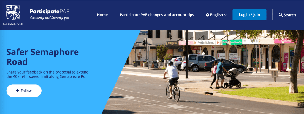
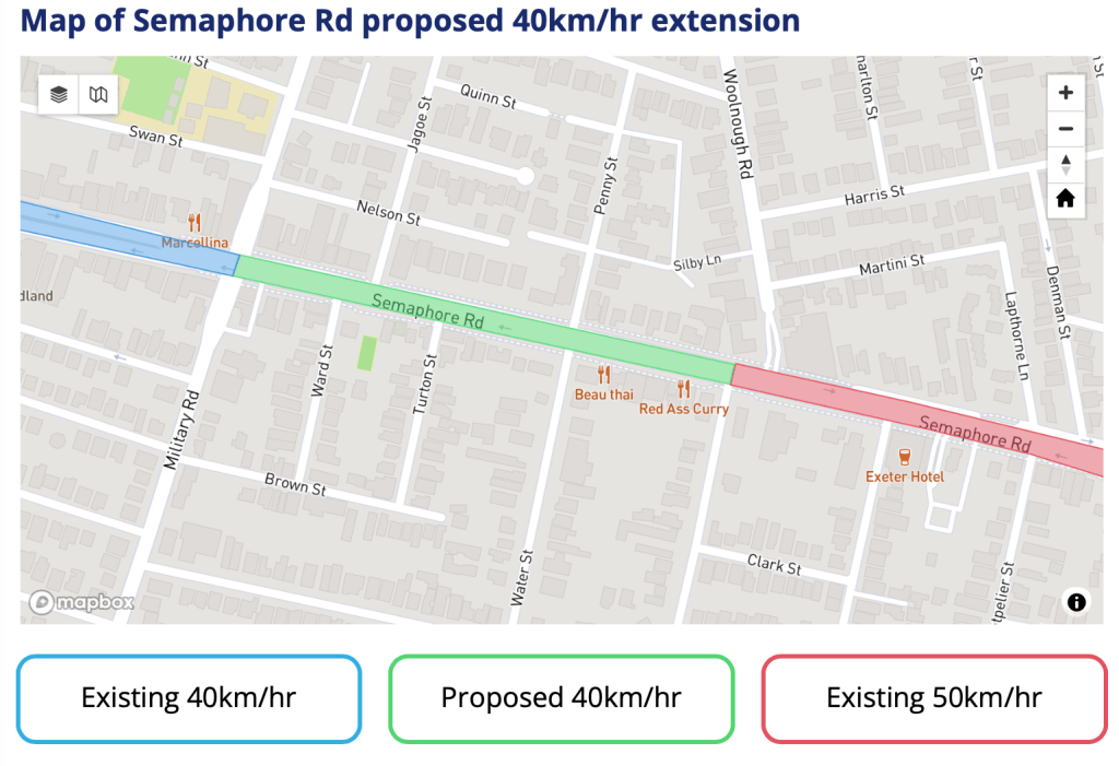
At the moment the 40km/h precinct extends from the Esplanade T-junction as far as the Military Road intersection – historically the location of Semaphore’s major shopping strip. The Council is proposing to extend the speed limit zone as far as the T-junction with Swan Terrace (adjacent to the service station), where an increasing number of shops & services have been opened in recent years (see green zone below).
PortBUG has long supported extension of the 40km/h speed limit precinct. However we would prefer that it extend the full length of the ‘single-lane’ section of the road – that is, as far as the junction with Causeway Road further to the east (including the red zone above). After Causeway Rd (& the railway crossing) Semaphore Road becomes a dual carriageway with 2 traffic lanes on each side of the road, & higher numbers of trucks & commercial vehicles, Causeway Road being a designated heavy-vehicle ‘by pass’! All sections of the road shown above are single lane!
Those familiar with Semaphore Road will know that the complexity of the junction of Semaphore Rd with Swan Trc & Woolnough Rd – at the left hand end of the red section above – while much improved in recent years, still presents all road users with a challenging situation. Many will also know it as the location of a fatal collision involving a very well known local a few years ago.
It’s also quite obvious that the entire single-lane section of the road (Esplanade to Causeway Road) is now quite intensively populated with many small business & service premises, quite a few residential frontages & many driveways & side road junctions. Several new & quite large business & service premises (including vet & health centres) have recently opened along this eastern section of the road & more are anticipated given the proximity of the new housing redevelopment around the Inner Harbor.
Given the presence of these new businesses & increased parking & pedestrian activity, as well as the on-road bike lanes & increasing bicycle use, PortBUG believes a 40km/h limit is more appropriate than the current 50km/h. It is certainly an adequate traffic speed for such an environment & when traffic is heavy it’s often not possible to go faster. A comprehensive 40km/h limit as far as Causeway Rd would more clearly differentiate the heavy vehicle, dual carriage way from what has now become a much more uniform & single-lane shopping, service & ‘pedestrian-intensive’ strip!
PortBUG strongly encourages your participation in the Council’s ‘Have Your Say’ consultation process which you’ll find here.
PortBUG & Bike Adelaide met again with members of the Port Dock Rail Station design team yesterday to review progress with their planning. Representatives from Bike Adelaide & PAE Council was also present.
Unfortunately the meeting saw no resolution of the key issues we have raised to date, notably the likely disruption of existing walking, cycling & active travel activity in the area directly affected by the project due to the:
removal of the current level crossing across the rail tracks adjacent to the Aviation Museum
closure of the Greenway entrance/exit on Lipson St.
Pedestrians & bicycle users travelling into the Port CBD will still be faced with 2 choices:
climb up & over the Red Hill Bridge & then travel down to the southern end of Lipson St (or on to Commercial Road) or…
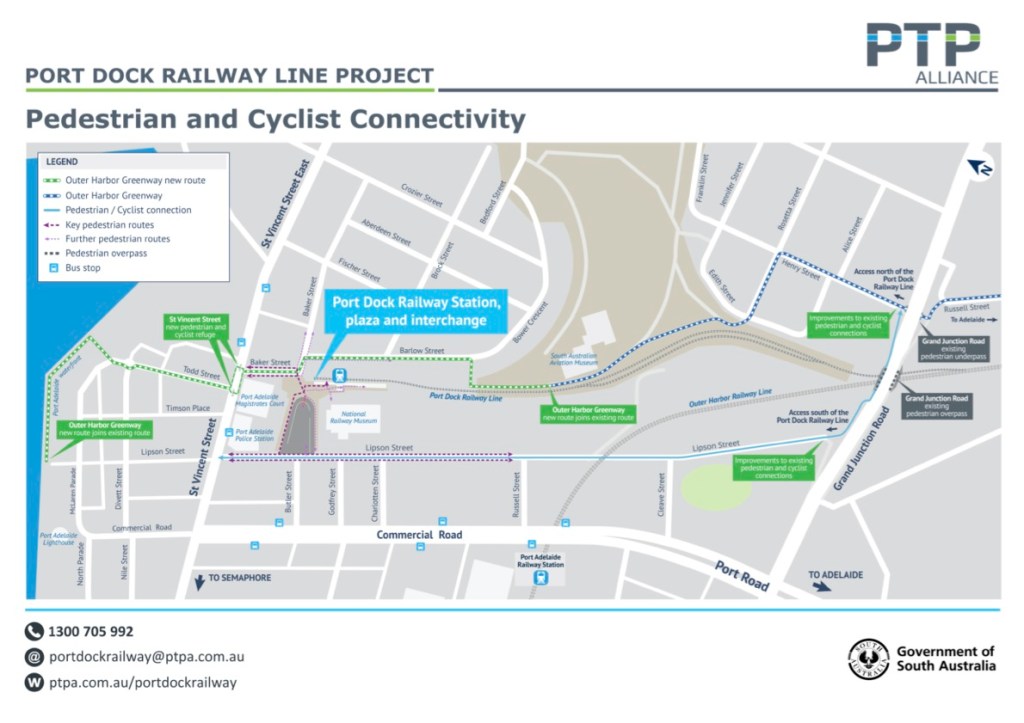
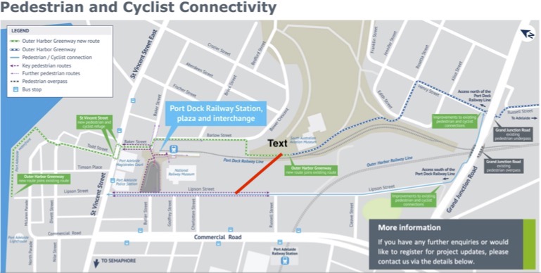
travel along the eastern side of the new rail line (via existing pathways & Barlow St) & then turn to the left through the new rail station precinct & car park/bus interchange to enter or cross Lipson St (see blue-dotted rectangle in our header image & the ed dotted line in the connectivity map below).
Apart from protesting the closures & pointing to the obvious inherent hazards & inconvenience of the obviously ‘non-compliant’ Red Hill Bridge route in particular, we have raised several other issues including need for improved pedestrian & cyclist crossings at both St Vincent Street & across Lipson Street (opposite the proposed car park & bus interchange).
The designers have come up with some bicycle refuge & crossing options at St Vincent St which should make the crossing relatively safe for experienced bike users. Unfortunately little further thought appears to have been given to the safety of pedestrians crossing St Vincent Street nor for those needing to cross Lipson St – either travelling to or from the train, or because this crossing point is the preferred route through to the Port’s CBD.
This was disappointing given concerns we have raised in previous meetings. PortBUG expects road safety for those crossing Lipson & St Vincent Streets to be a major consideration given the location of the new rail station, yet it appears to have been given no thought at all! Following yesterday’s discussion the designers have undertaken to get together with Council to see what might be possible at the likely crossing point on Lipson Street, bearing in mind that Lipson St is also a B-Double route! On an encouraging note, Council tell us that Lipson St is likely to become part of a general ‘Port CBD’ 40km/h zone in the not too distant future!
With regard to the proposed Red Hill Bridge crossing (refer to the arrowed blue line in our header pic & below) – apart from some realignment of the ramp way’s entrance the project will not be investing in any improvements to the steep, narrow, poorly protected & non-compliant pathway at all! Nor will they project be investing in lighting or surface improvements on Barlow St (solid green line) – although we do understand that Council may be able to do something in this regard.
The project will be improving the 2 abrupt corners at the Barlow Street/Rail Yard entrance & exit with wider radius turns & improved sight lines. They have also undertaken to see what can be done to improve sight lines at the junction of Barlow & Baker Streets although options here seem limited. Our Bike Adelaide colleague spoke strongly to the need to ensure safe routes for bicycle users through the car park/bus interchange area (blue-dotted rectangle) & the project has undertaken to look more closely at what can be done.
Previous discussion of the Port Dock project here.
From an active-travel p.o.v this is quite a complex project that will have a significant impact on walking & cycling access into & around the Port CBD. Options to improve things appear relatively limited – these seem to be the realities we face when different transport modes compete for limited space & funds! PortBUG will stay engaged & report as best we can on any further developments.
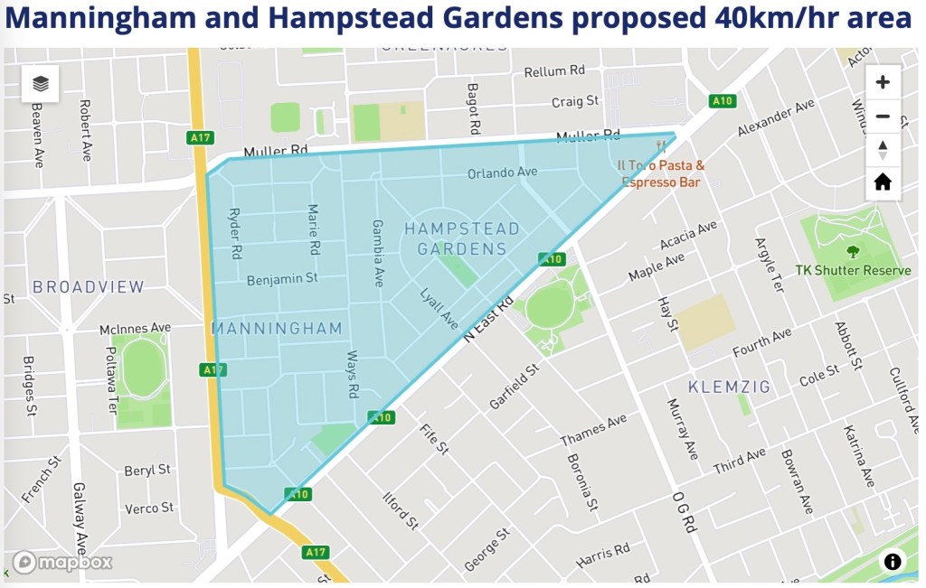
Port Adelaide/Enfield Council are conducting further public consultations for establishing 40km/h area speed limits for Manningham & Hampstead Gardens.
From an Active Transport perspective these speed limits are an important step towards a safer traffic environment for pedestrians, bicycle users, those using mobility devices & others.
You can read more about the project & have your sayhere.
Red line shows the approx. position of the current OHGreenway rail crossing & exit to Lipson Street.
The project will have a major impact on access on walking & cycling in the area. PortBUG has been involved for some months – often in somewhat fraught negotiations – in an attempt to preserve some semblance of convenience, connectivity & amenity for the many cyclists & pedestrians who make daily use of the Outer Harbor Greenway, and in particular the railway crossing adjacent to the Aviation Museum & the current exit onto Lipson St, both of which will be closed!
This removal will create very obvious barriers for those needing direct access to the Port CBD’s shopping & services. The project has made no attempt to survey or acknowledge this impact on Greenway users & local residents. Alternative routes proposed by the project team are generally unsatisfactory & will impose significant inconvenience & an unnecessary burden of risk on pathway users.
There will be particular impacts for residents of Ottoway & Rosewater seeking access the Port CBD. These people will be forced to travel considerable distances to the north or south, either:
• via Bedford & Baker Streets (to the north), exiting either through the rail-station car park (to Lipson St) or onto extremely busy St Vincent St or…
• up & over the Red Hill Bridge (to the south) & thence to the southern end of Lipson St.
These alternative routes impose increased travel distances of 1.7 km or more. The route over the Redhill Bridge also presents more specific safety concerns! It will utilise the existing narrow & steep ramp to the bridge-level footpath, also very narrow & poorly lit & protected from motor traffic. Neither of these paths meet relevant standards for ‘vulnerable users’ – pedestrians, children, cyclists, the aged & those with disabilities – nor are they appropriate for a major active travel route. The proposed ‘bridge route’ will clearly be noncompliant & present many ‘predictive risks’.
The other route to the north takes Greenway users either to an exit onto (or across) St Vincent St or to Lipson St via the new rail station concourse & car park/bus interchange footpaths. Again, for those travelling into the Port CBD, both present extended travel distances, increased inconvenience & certainly increased exposure to a range of ‘predictive’ traffic hazards.
It’s also worth noting that loss of the rail crossing & Lipson St exit has significant implications for Council’s Rosewater Loop Project, particularly its provision of direct & convenient connection into the Port CBD. Rosewater Loop users approaching via the Giillman reserve pathway & seeking access to the Port Plaza (Aldi, K Mart, Coles etc) will be required to ‘backtrack’ some 400 metres south to proceed over the Red Hill Bridge or proceed via an even longer distance to the north. Given Council & community investment in the Rosewater Loop project, the closures seem quite ill-advised!
PortBUG regards this outcome as unsatisfactory & unnecessary. The Port Dock design team has made a great deal of ‘improved safety’ for pedestrians & cyclists with the closure of the level crossing. We have argued strongly for retention of the current crossing and the installation of new ‘automatic’ crossing gates. These gates are already widely used in rail station precincts across Adelaide & have proved very effective, particularly in improving safety for wheelchair & mobility device users as well as for children & the elderly.
We have had several discussions with Council officers, who we believe share our concerns. We have also written to both Deputy Premier Susan Close (Member for Port Adelaide) & the Hon Joe Szakacs (Member for Cheltenham), outlining our arguments & seeking to meet with them (no response as yet).
We encourage readers to familiarise themselves with the proposal & plans & provide feedback accordingly.
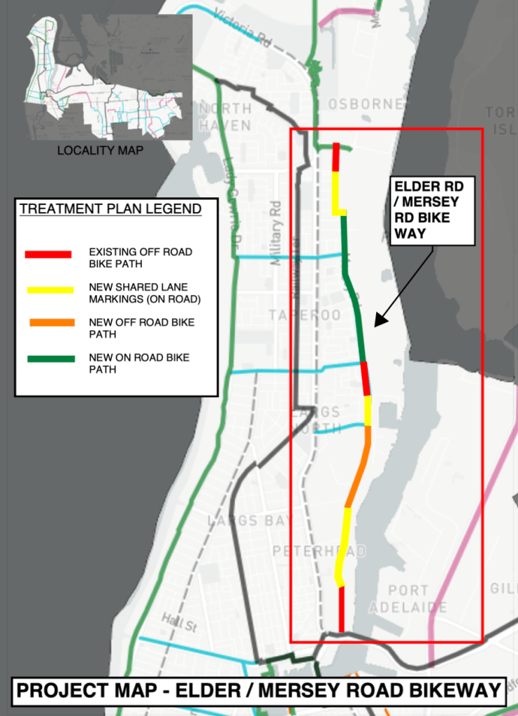
a proposal to greatly improve the Mersey Road Bikeway routewhich runs northwards between Victoria Road & the Port River. The proposal would create an ‘on road’ bike way with new infrastructure along Elder Rd and Mersey Rd, running from Birkenhead to Osborne
the ongoing identification of new locations for additional bike parking facilities and walking & cycling refuges across the PAE council area.
“We have identified that the Mersey Road bicycle route is an important secondary route linking the employment centres within the Lefevre Peninsula. We are proposing several treatments along this route to improve cycling. Different treatments have been selected based upon the streetscape. A separate path has been provided where there is sufficient width within the verge. For sections of Mersey Road that are greater than 9m, we can re-allocate space within the existing road cross-section to provide a dedicated on-road bicycle path while still maintaining two travel lanes for traffic and parking on the western side (property side) of Mersey Road. At other constrained locations, we are providing the ‘shared road’ pavement marking to highlight this is part of a cycling route. We have been successful in receiving grant funding under the State Bicycle Fund for these improvements.”
And here’s a short summary of new bike parking & median refuge possibilities:
“We have been successful in receiving funding through the State Bicycle Fund to help deliver the cycling projects detailed below in our Next Steps [including] installation of [bike parking] hoops and consideration of bike refuges around the City of PAE. We want your help to decide where this infrastructure should be located and to review existing infrastructure that may not be meeting… needs due to poor location or condition.We are unable to install hoops on private land such as privately owned shopping centres however please tell us about these locations, and we can pass this feedback on.
Refuges allow people walking and cycling to cross main roads in two stages so they only have to deal with one direction of traffic at a time. The refuge provides room to stop in a centre island. They are particularly beneficial on busy roads where it may be difficult to find a safe gap in both directions of traffic. We are seeking your feedback on where these are needed most.”
Implementation of the new 5-year Walking & Cycling Plan takes an entirely new approach. – it will largely be based on ongoing feedback & participation from & by the community. So we’ll see the best outcomes if the community gets involved! So we strongly encourage PortBUG members to get involved & take this opportunity to comment!
It’s also worth noting that – as well as the State Bicycle Fund money mentioned – Council has allocated a considerable sum of money from its own budget for annual implementation of The Plan over its initial 5 year span! So you can be confident that Council officers will be listening to what you have to say & there’s a good chance that any suggestions you make will be implemented!
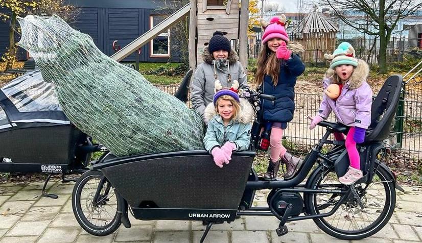
Australian Cargo Bike retailer, Dutch Cargo Bike will be holding a freeCome & Try Day here in Adelaide. If you have any interest in cargo bikes & their car-replacement possibilities hit the Greenway (or bus/train) & check it out.
When: May 6th, 9am – 12pm.
Where: The Joinery, 111 Franklin St, Adelaide.
Please Note: Limited street parking – take your bike or PT.
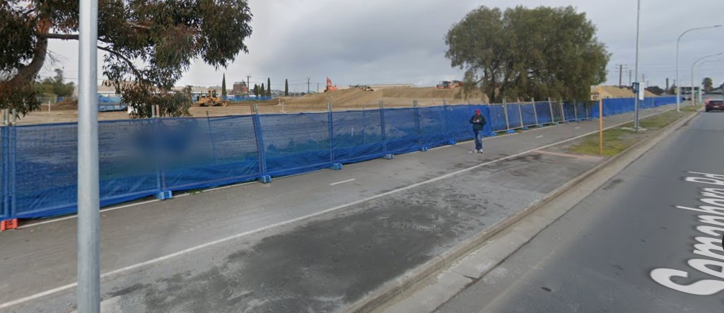
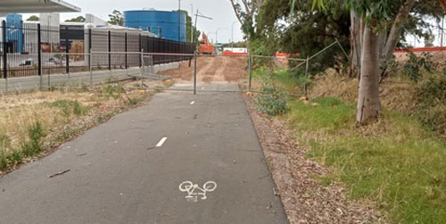
Gawler Greenway users will have noticed (perhaps ‘run into’ is the better term) the closure & disruption of the pathway adjacent to Grand Junction Road between Narweena Drive & the nearby underpass.
Unfortunately PortBUG only became aware of this belatedly when Michael Palmer, BikeSA ride leader reported the situation to us in mid-January. By then it appears that the Greenway had already been blocked for several months by a new access road, created for the construction of an enormous MainFreight facility immediately to the south!
Gawler Greenway closure (looking west).
No onsite maps or signage were provided & pathway users were required to ‘wing it’ – figuring out an appropriate detour on their own & crossing Grand Junction Road with no guidance to the safest crossing point or how to reconnect with the Greenway route!
“No Pedestrian Access – Use Alternative Route”.
The BUG immediately reported the situation to PAE Council staff who contacted the Emmett Property project manager involved. Incredibly – remember this is 2023 in the self-titled ‘cycling capital’ of Australia – Emmett plead ignorance of any need to consult Council regarding the closure of the Greenway!
Even more difficult to understand was the lack of any obvious concern for the safety of pathway users or attempt to re-route Greenway users in a safe & organised fashion. This stands in great contrast to the efforts that developers of various construction sites at Bowden, where site managers have gone to considerable lengths to safely manage closures & impacts on the Outer Harbor Greenway!
Fortunately Council staff were able to get a commitment to reopen the path this week so no temporary detours on their part were required. Michael has reported today that “the surface has been reinstated with tarmac as per photos (see below). As you will see there is the ramp from the service road to be finished but otherwise all good”.
New tarmac & pathway restitution.
New access road crossing & ramp installation.
The lesson for us all from this incident is to report any problems on our cycleways to the local Council (or to your BUG) asap! Council is in the best position to negotiate appropriate detours, alternative routes, advisory signs or repairs required & will usually do so in consultation with the BUG & cycling community.
Council will monitor the final reinstatement of the pathway over the coming week. Obviously the new access road is likely to be in frequent use so we’d suggest all pathway users take extra care at this point. We may ask Council to ensure appropriate warning signs are installed for both pathway users & drivers! Thanks to both Michael & Council Staff for their persistence in following up this matter!
Hi Folks, PortBUG has been quiet for a couple of months… but we haven’t gone away! We’ve been weathering the COVID storm & awaited Council’s ratification & implementation of the new Walking & Cycling Plan. So check out the important news & consultation opportunity below…
New Walking & Cycling Plan:
Council has now adopted the new 5-year Walking & Cycling Plan & has also made a significant commitment towards annual minimum funding for the Plan for the next 5 years with the following focus areas:
Improve walking and cycling infrastructure
Promote and encourage walking and cycling
Provide information, invest in data and monitoring.
First Steps – 2022-23: As a first step, for the 2022-23 financial year the Council has obtained funding for cycling projects in the following 3 areas:
Port Adelaide CBD Cycling & Walking Networks: Aims to define cycling routes throughout the Port Centre, ‘. This initiative ‘leveraging’ off the ‘Outer Harbour Greenway’ as a major cycling corridor & providing alternatives for cyclists to better link them to services and destinations within the Port.
City Wide Secondary Bike Paths: This project will promote ‘neighbourhood cycling routes’ for the community & increase awareness for motorists to ‘share the road’ on these neighbourhood connections. It will formalise neighbourhood connections with appropriate signage & line marking along with other supporting infrastructure improvements, such as path linkages and kerb ramps.
City Wide Cycle Parking Facilities: Will provide end-of-trip facilities – cycle parking – at key locations & community buildings across the City.
Council is conducting an on-line ‘Have Your Say’ Consultation to identify locations for new, additional & improved Bike Parking & Cycling Refuges – additional bike parking ‘hoops’ & bike refuges at road crossings. Where do you think new bike parks & crossing refuges should be located & how can existing infrastructure be improved, relocated or better maintained? Please let Council know what you think!The Have Your Say form & page are here…