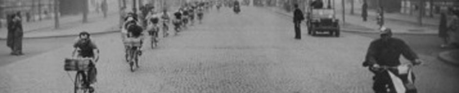

Entrance driveway – Eastern Glanville Station car park. Station platform just to the right of the sign.
As Port Adelaide, Semaphore and other local residents may be aware, DPTI has posted signs at the entrance to Glanville Rail Station’s eastern car park indicating that it will soon be closed permanently with the start of the ‘Fletcher’s Slip’ housing project.

Closure area cross-hatched in red.
The signs tell us that:
- virtually all of the eastern car park will be taken up by the housing development
- the only east-side access remaining from Semaphore Road will be the relatively narrow paved footpath next to the rail reserve fence (courtesy of Cedar Woods who now own the footpath too!)
There seems no acknowledgement of Active Transport issues or provision for safe bicycle access to the Station from the eastern side, nor does there appear to be room allocated for bike storage and ‘bike-’n-ride’ facilities. Thirty-five ‘park-’n-ride’ car-parks will be lost, including 2 reserved for people with disabilities!
Although some closure of a section of the car park appeared in the original ‘concept’ plans we have seen, it had not been clear to us that so much space would be lost from the station precinct. Most of the plans we’ve seen show the development area following (or paralleling) the curved line of the existing boundary fence, leaving most of the car park area intact! There has been (as far as we know) no specific community consultation regarding this closure and its likely community impacts!
This closure raised a number of questions for the BUG:
- will the shared-use pathway (SUP) on Semaphore Road remain open?
- will the footpath into the station platform remain open?
- will pedestrian, wheelchair, mobility device, disability and bike access be improved (wider pathways, better ramps, wider radius corners, better lighting, more even surfaces, reduction of ‘predictive hazards’ etc)?
- how will safe and convenient drop-off points for train travellers be maintained or improved?
- how will the long-discussed (& more-or-less ignored) issue of adequate & secure bicycle parking at the station be progressed with the loss of space for a bike storage enclosure?
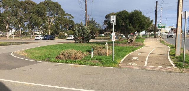
Bicycle users can currently enter the car-park from the shared-use path via the paved driveway. This will close!
PortBUG has spoken to the Development Manager for the Fletcher’s Slip Project. He has told us that:
- DPTI are responsible for all signs and ‘public notifications’
- he anticipates a public notice period of 2 weeks prior to closure (suggesting closure on about Monday 24th June).
- the developer, Cedar Woods now own all of the ‘car park’ land up to the fenced edge of the rail reserve and between Semaphore Road and the station platform entrance
- the SUP along Semaphore Road will remain open (barring occasional short-term closures in the interest of public safety)
- pedestrian access on the existing footpath along the rail reserve fence will be retained
- the Project will provide 2 x disability-compliant access points on the eastern side of the rail station (one at each end of the platform).
The BUG has indicated our concerns about these outcomes, notably:
1. Bicycle/Active Transport Access: It appears likely that we are not going to see Aust Standard bike access to the eastern side of the rail station. The Development Manager talked of ‘maintaining the status quo’ by retaining the existing Station Footpath. The current pathway is less than the required 2.8m width for a shared-use pathway in this context, is severely impacted by tree roots with extremely uneven surfaces, inadequate ramps, tightly radiused corners and significant ‘predictive’ user conflict points.

Acute, tight radius turns at the station pathway entrance & numerous potential ‘user conflict’ points.
The Station Pathway needs significant redesign and reconstruction if it is to approach an appropriate standard as a multi-user station access pathway (too narrow for multiple user access, poor sight lines, junction orientations and angles). Given the extensive incursion of tree roots it also seems highly likely that all of the established trees along the rail reserve fence will be removed!

Station fence & established trees (& tree roots) on the right of Station Pathway. Note uneven surfaces & root incursions!

One of several instances of root damage to the Station Pathway.
It is clearly not possible to meet Australian Standards for station access here simply by retaining the existing pathway! It is important to consider that this single pathway must of necessity function as a shared-use & multi-user access point (disability and mobility-device access, pedestrian and more vulnerable community access, bicycle users, child-carriers and prams etc.)
2. Current & Future Bike Parking: The area of land excised from the station precint removes space needed for both a secure ’swipe-card access’ lock-up bicycle parking enclosure and for more casual bike-parking racks. Currently there is little or no room for such facilities on the western side of the station precinct (this being taken up by a bus interchange, access pathways and a small commuter car park). Provision of secure and adequate bike parking at Glanville Station has long been the subject of discussions with both DPTI and the PA/E Council. It must be asked how the sale of this land to Cedar Woods has occurred without reservation of space for secure bike parking and storage?

Adelaide’s secure ‘swipe-card’ bike parking enclosures.
Passenger Drop-off, Pick-up & Car Parking: The closure of the eastern car park removes 35 car parks (2 disability) and a safe and convenient drop-off point for passengers arriving by car. There is no way that car passengers can safely alight on Semaphore Road. The only other potential drop-off and pick-up access points are the bus interchange and small 25-space car park on the western side of the station platform, accessed from busy Causeway Road. The interchange is currently reserved for buses with no allowance made for cars delivering or collecting passengers. Significant redesign would be required to make a shared-space possible (if indeed there is room to do so). The separate western commuter carpark next door is extremely narrow (essentially single-lane along its entire length and certainly with a single car width driveway), has only 25 spaces, no specific designed drop-off point and is difficult to enter and leave with driveway access requiring a sharp 180 degree left turn. This driveway is also quite a dangerous exit point onto a high-speed road with frequent heavy vehicle traffic.
The closure of the eastern car-park will have very significant and deleterious outcomes for train travellers and station users generally. Overall station access is likely to end up substantially restricted and less secure, especially for those:
- with physical, sensory and related disabilities
- arriving or departing by car
- commuters arriving by bike or leaving their car or bicycle for the day.
From PortBUG’s view point that this station closure is clearly the result of poor planning, a lack of public consultation and inadequate consideration of community needs. At the very least we’d like to see The Fletcher’s Slip Project widen and resurface the proposed eastern access footpath, improve sight lines and widen turning radii at the corners. The redevelopment should also provide adequate space on the eastern side of the station precinct for lock-up bike parking as well as open-rack bike storage.
We would also like some assurance that both PA/E Council and DPTI have a plan to redesign the station precinct to ensure that the needs of all public transport users can be met – now and into the future – particularly with regard to the likelihood of greatly increased train travel and the inevitable growth of ‘cross-modal’ travel behaviours (‘park ’n ride’, ‘bike ’n ride’ etc).
We have more photos posted at PortBUG’s facebook forum which further illustrate our concerns. The PortBUG has communicated these to the PA/E Council and will write to both the developer and the Minister for Transport in the coming week, asking that urgent consideration be given to both public consultation and improving development outcomes for all public transport users.
To be closed: the Semaphore Road entrance (left) to the eastern car-park. The closure extends from behind the photographer to beyond the parked cars and 100metres to the left.


