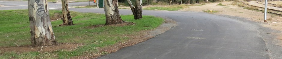

Redeveloped Woolnough/Semaphore Road Junction.
1. Woolnough/Semaphore Road Junction: Several years ago a tragic pedestrian fatality at the corner of Woolnough and Semaphore Roads prompted many requests that Council improve safety at this important footpath and bikeway road crossing. In particular the PortBUG asked that the speed of traffic turning right into Woolnough Road be constrained by the westwards extension of the existing median island.
Council has now commenced work on a major upgrade of this intersection, including traffic management measures for vehicles issuing from the adjacent service station and nearby Swan Terrace.
Key points identified thus far in the plan include:
- installation of a raised (100mm high) pavement ‘platform’ across the Woolnough Road entrance and exit lanes (orange coloured in the plan above)
- retention of bike and pedestrian ramps (reduced from 150mm to 50mm deep – better for walkers, prams and mobility devices)
- an additional triangular traffic management island managing traffic turning right from Swan and right into Woolnough
- right turns from the service station exit now banned (except for tanker exits about 1 x week – the new triangular island will be a ‘drive over’ type)
- the existing linear median on the eastern side of the intersection (alongside the right-turn lane into Woolnough) will be extended westwards by approx 3 metres to constrain turning speeds.
Although the overall functioning of the redeveloped intersection will be more apparent when it’s finished, it’s encouraging that Port Adelaide/Enfield Council has taken on board the obvious safety issues PortBUG and the community have raised! These works cost about $230,000 and have been part-funded by the State Black Spot Program.

Proposed ‘Rosewater Loop’ Pathways.
2. Proposed ‘Rosewater Loop’: Council have informed us that they have applied for funding for a new ‘Rosewater Loop’ shared pathway (marked in red above) that combines two bikeways that we have long sought separately:
- a new bikeway along the now-disused Rosewater Rail Line extending through Rosewater and across Grand Junction Road to loop around the northern margin of Ottoway
- the extension of the ‘Gillman Railyard Pathway’, currently existing (in a formal sense) only as far as McNicol Trc. The track beyond this is an informal one ‘made’ by users walking to and from Ottoway, either all the way to Eastern Parade, or zipping into Ottoway via a ‘doorway’ cut in the rail line fence at the corner of Railway Trc.
Council expect to hear if they have the funding within a few weeks. If successful this shared-pathway loop will provide safer Active Transport access (for walking, cycling & mobility devices) for Rosewater residents to shopping and services on Grand Junction Road as well as to the Alberton Railway Station. It will also provide much more direct access for Ottoway residents to the Port Adelaide CBD via the Outer Harbor Greenway pathway.

New Regency Road Bikeways (marked in red).
3. Regency Road Bikeways: The BUG has long argued for off-road linkages between the Gawler Greenway route along Narweena Terrace and the East-West Connector route running from Port Adelaide, through The Parks to Days Road. There are now two new off-road pathways under construction along the road-side reserves on Regency Road that will provide this connection (marked in red above).
Both of the new pathways are on the northern side of Regency Road. One extends from South Road to Days Road past the TAFE, the other linking the crossing at South Road via a pathway in front of Coopers Brewery to Narweena Trc (& the Gawler Greenway). These pathways will provide useful linkages between key bikeways across our Bike Network.
4. New Port Adelaide/Enfield Bike Plan: The current Port Adelaide/Enfield Bike Plan concludes in June this year. Council has provided funding for development of a new Bike Plan over 2020-21. PortBUG is developing an agenda for the new Plan and our own community consultation strategy that we hope to share with readers asap. We hope to utilise a ‘local scenario’ approach that will map out key cycling locations and provide opportunities for your commentary based on your own day-to-day cycling experiences (see a DRAFT example below). Stay tuned!

Example: Draft PortBUG Bikeway Commentary – Bike Plan.


